SALMON LIES (PART 2)
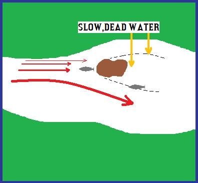
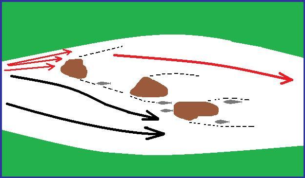
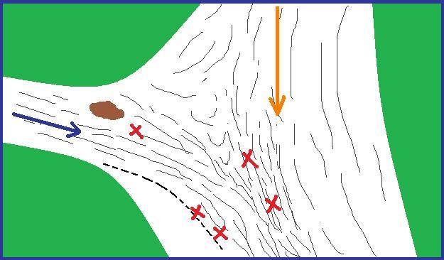
All anglers can remember various influences during their fishing careers that have helped them in obtaining a better understanding of the complexities and little nuances that are involved in the jigsaw like puzzle that salmon fishing sometimes seems to be. Every new piece of knowledge that we add helps us to form a more complete picture and also helps us to approach our fishing in a logical, confident manner. One of my own early influences was a book on salmon fishing by R.V. Righyni which was kindly given to me by my first mentor Ned Gallagher(now sadly passed on). Righyni’s book (Salmon Taking Times-published in 1965) was a mine of valuable information for a fanatical young salmon angler! . In the book there is a chapter on the behavior of water in rivers. The first three diagrams in this article are based on the content of this chapter in Righyni’s book, and will really help us to have a better understanding of the salmons environment. Reg Righyni was one of the best salmon angling writers of all time and probably never got the full recognition that the brilliance of his work deserved.
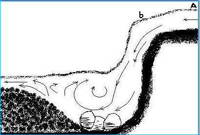
There are two different types of flow in rivers that are important to us anglers as we try to figure out the location of potential salmon lies, and in the diagram above which is a waterfall we can study water flow caused by suction. In the diagram the water current at A is very fast but that is not due to the immediate gravitational pull at that point because there the pull is vertical and prevented from operating on the flow, other than to keep the water compact, by the flat rocky bed of the river beneath it. At point B the force of gravity is able to assert itself and the water drops, and as it will not allow the formation of a vacuum, suction draws the water from A to replace it. The impetus of the falling water is largely lost when it reaches the bottom of the falls, and what remains is deflected in all sorts of directions. At the bottom in the falls pool the water has no inherent forward pressure to make it flow away. Consequently, a slight dome of water tends to collect, but gravity will not allow this to build up. The strong vertical pull on this extra surface water is deflected by the water beneath it (which cannot be compressed) into a much weaker, almost horizontal pull which causes the top layer of water to flow gently away. The subsequent behavior of that water flow depends on the changes in capacity and character of the channel through which it must pass until ultimately the water is again taken over by the influence of suction.
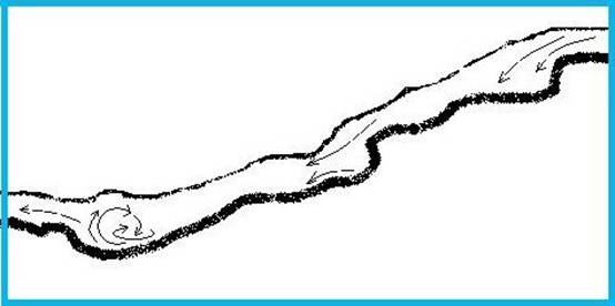
In this diagram above the more inclined fall results in a more gradual deflection of the movement of the water, and it loses considerably less of its impetus by impact with solid matter or other water than in our first diagram. Consequently the falls- pool does not get washed out as deeply, and is more elongated. Nevertheless, the back washes, and undercurrents still arise and the residual forward pressure is compelled to exert itself mainly on the surface layers.
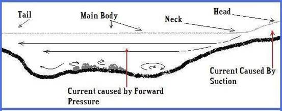
This diagram is a vertical section of an average sort of pool that is to be found on many rivers. It includes all the same features of a waterfall, but everything is elongated even further with the head being a rapid rather than an actual fall. Pools which are less well defined than the one depicted above are simply the same thing over again, but elongated still further, and the proportionate size of the component sections(Head,Neck,Main Body,Tail) can vary infinitely. Gravity is, of course, responsible for all the inherent flow of the river, but the effects of it are modified by other factors which deflect or transform the vertical pull into horizontal flow. When the gravitational pull can exercise itself forcefully on the water and is deflected by the slope of the river bed into horizontal or forward pressure, it is hardly possible in natural conditions for it to occur smoothly and evenly. Backwashes in all planes from vertical to horizontal are set up,and quickly,if not all together, the forward flow becomes concentrated in the level near and on the surface. The movement of this layer is resisted by the pockets of slack and swirling water beneath it. Unless some additional impetus is given to the forward pressure by a further drop in the bed of the river, it is quickly divested of its power, and the movement is reduced to no more than that required to equalize the level of the surface. It is necessary to try and visualize the essential differences between the two basic types of flow. Runs through the necks of pools and the streamy water in the wider shallow stretches have a rough or popply surface. The smooth surface water in glides and pool tails behave entirely differently. Here the water moves along en masse owing to the pull of the suction created immediately below, where a drop in the bed of the river enables gravity to take hold forcefully. As the smooth surface of the glide indicates, there is a minimum of turbulence at all levels, with the flow being nearly even from the bed of the river up to the surface The reason why we need to understand these different types of flow is because salmon will lie in both of them to varying degrees,but this will depend on many variables such as, time of year,time of day, light intensity, water temperature,oxygen availability,safety,water clarity, whether the salmon is a long or short term resident or just stopping for a short little breather as it runs upriver. Let us try and look at these two different types of flow in an even less complicated way and give them simple names such as SMOOTH GLIDEY FLOW RIPPLED EVEN FLOW We can now add a third equally important type of water flow and lets call it CHAOTIC TURBULENT FLOW
The first two we need to spend our valuable fishing time in and the third we need to avoid as there will be generally no salmon lying in Chaotic Turbulent Flow. The vast majority of fly caught salmon are taken in water that is 6ft/2 mts or less in depth, so even if the flow type that we happen to be fishing in at any given time seems to be ideal it is also important that it is not too deep. Fly fishing for salmon in water that is 9ft,10ft+ deep is usually very unproductive when using normal fly fishing techniques.
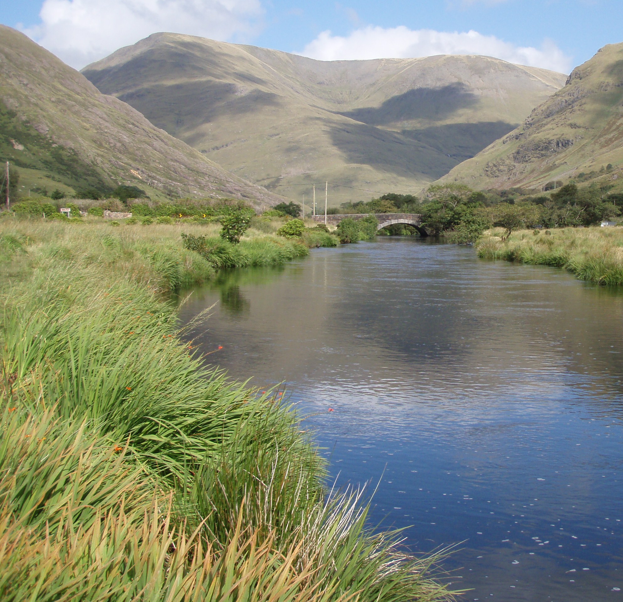
With the aid of some photographs we can now have a look at these three types of flow
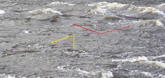
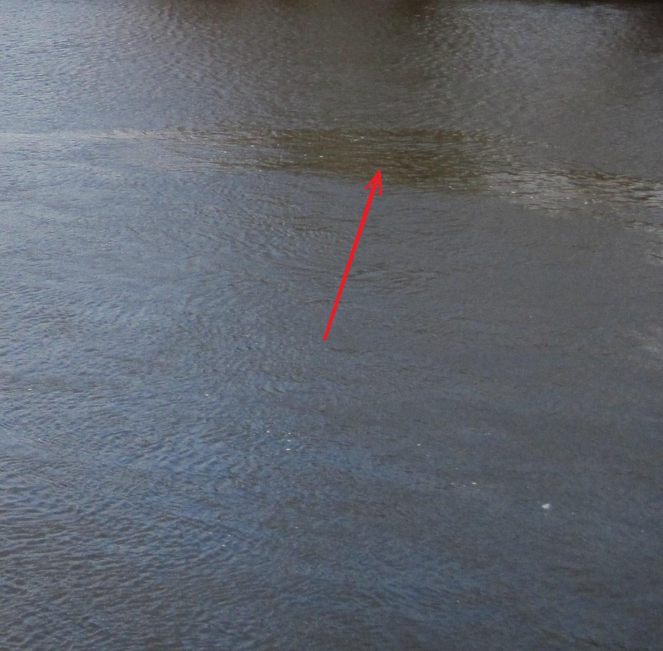
CHAOTIC TURBULENT FLOW – The red arrows points towards a very strong water current with its white tipped waves jostling for position!-too fast, too turbulent. The yellow arrows point to swirling,boiling and up-welling water. No salmon will lie in this type of water either. Fly fishing our way down through water like this is a complete waste of our valuable fishing time, and during the course of a weeks fishing holiday, it is a sobering thought to realize that we may have been fishing completely barren water for a substantial part of each day.
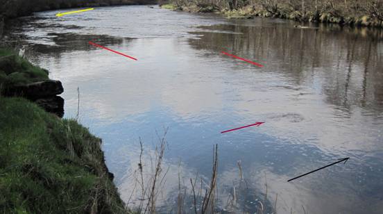
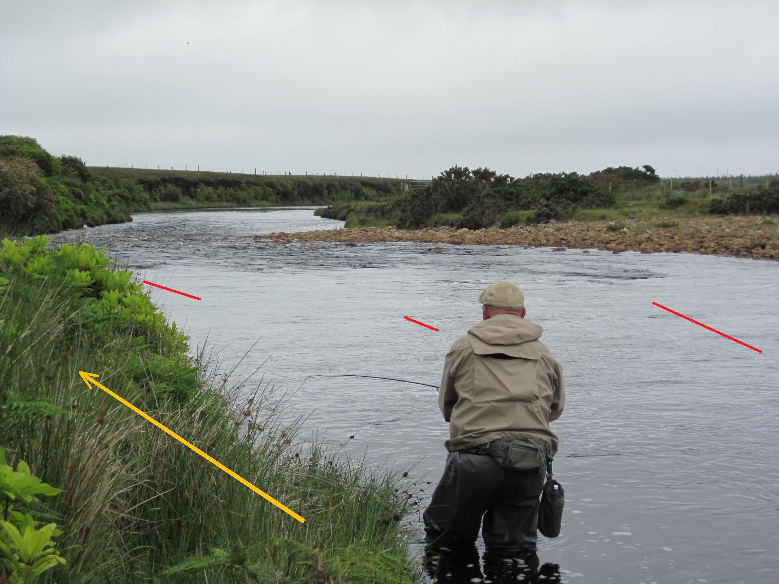
This is an interesting pool. The salmon run upstream from the pool below along the yellow line. From the point of the yellow arrow you will notice a smooth area and this is the tail of a mini pool (Smooth Glidey Flow) that lies between the yellow pointer and the downstream point of the red line on the left. This mini pool is fairly easy to spot in this instance, but other so called pools within pools are more difficult to spot, especially if the overall current is moving slowly. The smooth appearance of the water surface in this tail is easy to see at distance and would be even easier to see if we were looking upstream from further downriver. In fact all types of current flows along with all their varied little nuances reveal themselves much better to us when viewed from downstream looking upstream. The first red line on the left marks two salmon lies in the tail of the main pool and at this point the suction from the drop off below is really beginning to take effect –Smooth Glidey Flow. In low to moderate water flows running salmon will pause and hold here(along the red line), with some resting longer than they normally would in a pool tail because the overall speed of the river flow is moderate. When the river level is higher and the current stronger some larger fish still pause here, but smaller fish start to find this lie too uncomfortable, and start to lie along the red line to the right where the depth and flow rate suits them better. The purple arrow points at a whorl on the water surface caused by a large rock on the river bed. The black arrow pinpoints where the rock is actually situated, and you can see that it takes a little time for the effects of the turbulence around this rock on the river bed to actually reach the water surface downstream from its actual location.
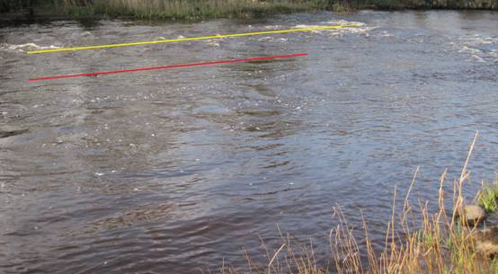
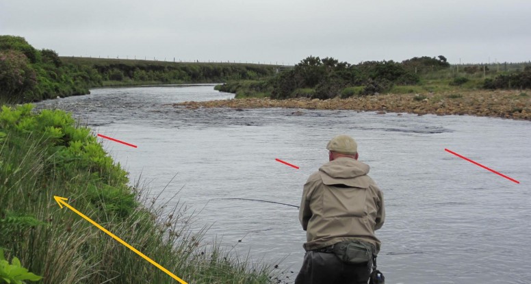
The red line indicates the position of three lies in a Rippled Even Flow. The yellow line is also in a current flow that is caused by forward pressure, but in this case it is too turbulent. When the water level in the river drops down a little more, and the pace of the main current along the yellow line decreases, then there may be some places along this area that may become more evenly flowing and steady where a fish might possibly lie. Running salmon will occasionally lie in this type of turbulent,fast water, but only when a large rock, group of rocks, or something like a ledge of some sort set at a fortuitous angle happens to buffer the current to produce a relatively even, slower, pocket of current flow. These potential lies in turbulent stretches of salmon rivers can be very difficult to spot, but if we remember to look out for evenly flowing, or better still, smooth evenly flowing, areas in among all the chaos, then we may discover some valuable new lies that we might have previously walked by. Not many of these fishy looking potential lies in turbulent water will actually hold salmon, because there are just to many things that have to come together perfectly to make a suitable lie in this hostile type of current, but enough of them will produce a bonus fish to make the effort of trying to discover them both enjoyable and worthwhile. There is still more to cover on this subject of where salmon lie in rivers, and in the next article we will try to click a few more pieces of the jigsaw into place. Until then, enjoy the spring salmon fishing, and remember don’t lift into those takers too soon!!
All the best
Paddy

